|
By Allison Batdorff copyright 2002 Manistee News Advocate
The Manistee River was one of legendary proportion.
Because of its underground springs, it was known as the river without drought, flood or freeze.
It had 400 miles of navigable waterways, defined as one capable of floating a log with ease.
It was home to human inhabitants for 10,000 years. It was fish and fresh water for the Native Americans and the bread and butter of the logging industry. It was transportation and hunting grounds for fur-trappers and fishermen. Abounding with resources, the Manistee River was
a waterway of unlimited potential.
It was Manistee's 'raison d'tat -- its reason for being, according to Steve Harold of the Manistee County Historical Museum. But to wade in its history, one has to be prepared for some muddy waters. The Manistee's history has as many twists and bends as the river itself.
Even the seeming constancy of the river's name and location is subject to debate.
"The names are all Indian," Harold said. "The others were just passing through."
However, those transients caused plenty of confusion. Called 'Manistee' by the first Native Americans, the word has many documented translations -- "the river at whose mouth are islands," "river with white trees along the banks," and "crooked river." There is another, more fanciful translation of 'Manistee' as the 'spirit of the woods.' Supposedly, at its headwaters around Deward, the 'spirit' would manifest itself through low howls coming from the trees.
However, historian Bob Adams says this is mostly malarkey. "It was the Chamber of Commerce definition at the time," Adams said. "It was a bad translation coming from mispronunciation." A historian of twenty years, Adams has come up with his own Manistee
translation from the Algonquin language. Dissecting the word into two parts, he said that 'mani' means vermilion, or a brilliant shade of red, and 'stee' means wood.
'Manistee actually means 'the river of vermilion wood," Adams said. He added that the 'stee' was mispronounced and should have been 'stique,' which would make the name of the town identical to Manistique, another city on Lake Michigan in the Upper Peninsula.
Little River Band of Ottawa Indians tribal ogema Jon J. Sam said the original name was completely different altogether -- Naminitigong or 'the place between the trees.'
Mispronunciation, bad translations and name changes are all problems common to the historical research done at the time, Adams said. There was also a major discrepancy in the physical placement of the river and where it sat on maps of old. According to a 1684 map configuration, the Manistee River ran through Frankfort where the Betsie River flows today. It was called the 'Aramoni,' which were the entomological beginnings of 'mani.' In 1688, it was referred to as 'La Manistie.' To add to the confusion, the river south of Frankfort (where the Manistee is today) was called the 'Pere Marquette.' It held this name from 1684-1796 until it became The Manistee. Its former name flowed downstream to Ludington in 1804 through which the current Pere Marquette runs today.
"You have to take everything you read with a grain of salt," said Adams. "These maps were drawn by people sitting around a desk in France. Only a few were key maps drawn directly from explorers notes." These mistakes have led to mystery and misconception -- especially in trying to locate Father Marquette's final resting place of May 18, 1685. Adams maintained that he died farther south on the Lake Michigan coastline, at Manistee -- neither in Frankfort, nor in Ludington where there are two state sanctioned historical markers proclaiming Marquette's death. His book "The Thirteenth River" outlines his research, which he augmented by floating
the rivers in a hand built canoe, using the navigational tools of the time.
NATIVE AMERICANS
But there were those who fished its waters and lived along its shores far before Pere Marquette ever set eyes on it. The first reports of the Manistee River come from the Native Americans whose lives moved with the rhythm of its waters. "The rivers, especially this one, meant everything to us. It runs right through our heart," said Sam. His family inhabited Manistee from its beginnings, which stretch a long way back.
Indian burial mounds, village locations and campsites have been found dating from 8,000 B.C. to 500 A.D. There are over 380 archaeological sites in the Manistee's watershed. At one time there were seven or eight villages that dotted both the east and west side of the Manistee's shores in Manistee County. The Manistee River watershed was controlled and inhabited by the "Three Fires" -- the Potowatami, Ottawa and Chippewa tribes of the Algonquin Nation.
They were largely nomadic tribes that summered on the southern rivers of the Grand, the White and the Muskegon. But in the wintertime, they always returned to the Manistee. "They knew they could survive on the river," said Sam. "The hunting prospects were better, the trapping prospects were better, it provided them food and transportation." They made their preference for the Manistee known when they signed the 1836 Treaty, which secured them 70,000 acres around the Manistee River; they ceded lands from the Grand River to the Straits of Mackinac in exchange the 22 x 5 mile reservation, education, training, hunting and fishing rights.
THE FUR TRADERS
The Native Americans guided the next group of explorers to the area -- the French fur traders. According to P.F. Powers, the Campeau's, a family of French fur traders from Grand Rapids, settled in Manistee in the 1830's. Jean Nicolet is credited with being northern Michigan's first European explorer in 1634, but Henri deTonti may have been the first European to float the Manistee River in 1679, unless it was Father Marquette in 1675. The Manistee River Ottawa became heavily invested in the fur trade themselves, Sam said. As his relatives inhabited the area from the beginning, he remembers amazing stories about his great aunt's parents who
would trap all winter.
"They would process the furs, bundle them up, and send them with an order form to the Sears Catalog Company," Sam said. "Sears would then send them what they ordered with the change if they sent too much." His family trapped well into the Depression, he said.
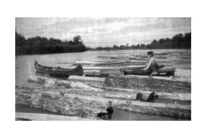
THE PIONEERS AND LOGGING
Traveling on foot or by boat along Lake Michigan, Manistee's first pioneers followed its serpentine course upstream. Some called its pine covered sand hills and plains "dreary and desolate." They never stayed long, until the 1830's when a group of settlers from
Massachusetts appeared and built a house on the river near where Tippy Dam currently sits today. "They brought a sawmill with them," said Harold. "However, after they built their house, it was reported that the Indians made menacing gestures, so they split." However, their house stood for many years afterwards, and was even used as a counterfeiters hideout in the mid 1800's.
The first settlers that stuck were the Stronach's, who arrived with a water mill on the Little Manistee River in 1841. Within a decade, they built three more operations, Harold said.
Then Joe Smith arrived, who logged off the first stretch of the Big Manistee, a five-mile stretch along where Manistee Blacker Airport stands today. Then the Canfields came and others, and by 1852, there were five mills operating in the area. They started logging immediately, without fussing with details like the actual purchase of the land.
"The first settlers didn't own the land they were logging," said Harold. "They just cut the trees down." Word of this got back to the United States government, and in 1850, war was declared on Manistee. The U.S. Navy was sent in to convince the settlers to buy the land from the government. Even the military incursion didn't seem to stop the fun and the loggers continued their business of cutting timber and building the beginnings of a new town.
By 1869, word of the Manistee River's bounty was growing. According to an account from A.S. Wordsworth, he described the spring-brook river as having tributaries abounding in waterpower, an ideal of logging pine timber and fruit growing on the lighter soils of Lake Michigan. Wordsworth compared the river to the state of Vermont, which at that time, was the richest state per capita in the Union. The river's drainage area was equal to the great state, but with better soil and a "less rigorous climate." It needs not a prophet to predict its future. Nothing less than a first class commercial city can meet the exigencies of its development."
Right he was.
Even in 1869, the Manistee River was well on its way to becoming one of the great logging streams of the country. By 1890, there were 25 companies operating 40 mills along the riverbanks and Manistee Lake, hungrily waiting for the endless procession of logs that
paraded down the waterway. "The town was built at the intersection of water and river to transport 400 miles of pine to create the third largest lumber center in Michigan," Harold
said.
Timber was the ore of the day, leafed gold that could be felled, stripped and sold literally 'down the river.' And from 1841-1926, Manistee cut and chopped itself into the great lumbering boom. "Whereas some communities would have river drives for a week or two,
Manistee's river drives would last six months," Harold said. "They carried logs to the river in the winter on sleighs." These loggers were protective of their turf. In the 1870's, there were
several attempts at starting a steamboat service on the Manistee River, to ferry passengers between Mesick and Manistee. But the steamboat idea sunk. "The lumbermen made sure of that," Harold said. "They didn't want anyone interfering with their logs."
So they cut. For five miles inland, along both banks, all the way down the river-400 miles of navigable waterways, they cut. But, like California's gold rush, it was destined to meet its end when the wells ran dry. Loggers had 95 percent of the timber down by 1895. A few managed to hold on until 1926 using the railroads to ferry their logs. However, the momentum had ceased, even before a new business prepared to flood America with cheap, water-powered energy, taking reign of the river.
HYDROELECTRIC POWER
The predecessors of Consumers Power were the early developers of the long distance transportation of electricity, and the Manistee River was an ideal place for their experiment, said Harold. "Essentially, they wanted to make free electricity, where the water does the work," said Harold. With high banks close to the river to ease dam construction and a high volume of water, the Manistee was chosen over other surrounding rivers. “It was proclaimed the last of Michigan's great rivers unharnessed and capable of producing 40,000 horsepower of electricity," said Tom Rozich of the Department of Natural Resources. With water flows as high as 3,400 cubic feet per second, Manistee's rate buried the Betsie rivers paltry 490 cfs and the Platte River's 210 cfs. Even the Pere Marquette River to the south generated only about half the flow of the mighty Manistee.
"High volume translates directly into power," Harold said. So three dams were proposed, the first was Stronach Dam, which was constructed on the Pine River in 1912. The second was far bigger and called Junction because of its location at the confluence of the Manistee and the Pine Rivers. Now called Tippy Dam, it was built between 1917 and 1920.
The third dam was called 'Coline,' because it straddled the Wexford and Manistee County lines. Now known as Hodenpyl, the dam was built in 1926-1928.
"The dams took a long time to construct," Harold said. "They also had to organize and purchase land around them." They flooded the river, creating the backwaters of Tippy Lake and Hodenpyl. It was no Tennessee Valley Authority situation -- all of this was done with
very little conflict from the public, Harold said. "The people of Manistee thought the dams were a great idea," Harold said. "It was a use for the cutover timber land that no one wanted anymore, and everyone wanted the cheap electricity."
Besides the economic development aspect, having electricity made Manistee quite cosmopolitan for the time. "The most modern, and up and coming towns of that time were the ones with electricity," Harold said. "Everyone thought it was great."Nowadays, there are differing opinions on the long-range environmental impacts of hydroelectric dams, but at the time, they were considered a boon for the town, Harold said.
THE RISE AND FALL OF THE GRAYLING
There was a cost to this "progress" along the Manistee River, a price paid by the Michigan Grayling. Beautiful, delicate and a sweet-tasting member to the Whitefish family, the Michigan Grayling was once abundant in the Manistee's waters. "Years ago, when northern Michigan was one vast primeval forest, the cool and shady streams which meandered through the pine woods and oak glades were the exclusive haunts of the grayling," said historical author Robert Porteous.
With an average length of 10 inches and weight of 10-12 ounces, hundreds of them could be caught in a single day. One report stated that three men caught 600 pounds of grayling, or 1,000 fish, in two days. The fishermen called the grayling by many names -- the white trout, the "Crawford County" trout, even the "Manistee" trout before it was given the scientific name of Thymallus tricolor in 1865.
Its discovery was unusual, in that there were none others like it in the country. This fish was of a breed more often found in the streams of England, Scotland and the Arctic regions. "The fact this fish was a native of the streams in the northern parts of Michigan was a great surprise to anglers and scientific men," wrote Thaddeous Morris.
However, the once healthy population sickened with the advent of logging. "The change in the Manistee River from a grayling to a trout river was attributed to competition, over harvest and habitat destruction during the logging era," Rozich said. By the turn of the century, the Michigan grayling was extirpated from the watershed.
This was a major problem for the Native American tribes that subsisted largely on the grayling, said Little River Band Conservation Department fisheries biologist Marty Holtgren.
According to Holtgren, grayling were reintroduced for a short stint in the 1930's. However, the experiment failed, largely because the conditions that caused the fishes' mortality largely hadn't improved. "There was also more competition in the water and still very little suitable
habitat for them," Holtgren said. "They are sensitive to sand, dams and overfishing." Now the grayling is extinct from the state. "It would appear that this fish is a child of nature and disappears at the onward march of civilization," said Porteous.
OTHER HISTORICAL HIGHLIGHTS
The Manistee River was a "late bloomer" in development terms because of a sandbar at the river's mouth and high-gradient water flow, a sand bar that still exists today. The first time the canal was dredged was in 1854-1855. The river was also cluttered with woody debris, and according to Rozich, it was rare to find a one-mile stretch of open water that wasn't choked with logs and log jams before 1870. Some of these logjams were huge, reaching almost 30 rods, or about 500 feet across.
The Manistee River is the historical home of the largest bridge project in Michigan (at least until the Big Bridge across the Straits of Mackinaw). Called High Bridge, the railroad bridge stood 78 feet above the water line outside of Brethren. Unfortunately, very little publicity was given to its construction, because of a disagreement with the news media, said Harold. "The railroad was originally supposed to cross the river much closer to town," said Harold. "And the newspapers thought it was going to be wonderful. But when the plans came through that the bridge was going to built 20 miles out of town, the paper largely ignored it."
A LOOK BACK
On the river, one can only imagine what's beyond each bend. But a look behind affords an entirely different view of the river, and a backwards glance often gives the best landmarks for navigation. What happened on the Manistee River was later imitated around the country --
in both its mistakes and its fortunes, according to Sam. "With its tribal relations, timber, salt businesses and the growth of industry, Manistee was a microcosm of how America grew," Sam said. "It all happened right out of this river."
|