|
|
Our adventure down the Length of the Manistee River, 185 miles, is chronicled on this and following pages. The articles appeared in our local newspaper, the Manistee News Advocate, on October 24-26 and all are written by Allison Batdorff (unless otherwise noted). Some are of local and regional interest, others may be interesting to anyone who enjoys a good story. We hope you will enjoy your virual trip down the Manistee
AROUND THE BEND: A Look at the Manistee River
By Allison Batdorff
©2002 Manistee News Advocate
The River tells a story in many ways. It's told in the movement of the waters, its current and eddies, its riffles and wakes. It's told by the fish and fauna to which it gives food and shelter. It's told in the ebbs and flows of its history, its environment and its impact on the people who live on its shores and fish from its waters.
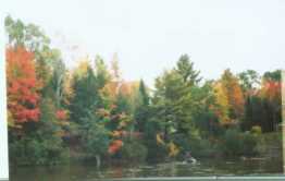
Two weeks ago, the river's story was told to me in the sound of waters lapping alongside a canoe. I floated along the river for week and was nourished by its waters and scenic views. I got cozy in its current. I was its passenger and I listened close to the river whispering.
Here the river's story will be told as if you too were a passenger. Once afloat, we will look at the river for what it is; we will look behind us to get our bearings, then we will paddle forth in the future.
Around each bend, the Manistee River has a story to tell. It's a story that rushes in places, but slows down in others as it unwinds its yarn. It's a long story --as many as 198 miles long. And it's an old story --about 16,000 years old.
Its a story with a beginning in the old lumbering era town of Deward and ending in a bustling Manistee port of Lake Michigan. It's story involves a cast of thousands in the creeks, streams, lakes that spring from her waters and the multitudes of people who visit it every year.
"Its a jewel," said DNR Fisheries chief Tom Rozich.
On a map, the Manistee River looks a bit like a curling ribbon that stretches across the state like a present. Curly and kinky in some places, straight and fast in others, it unravels halfway across Michigan, forming one of the longest water corridors in the state.
Starting from headwaters in Antrim County, the Manistee snakes through four others, including Crawford, Missaukee, Wexford and Manistee.
Its watershed covers 1.3 million acres and 2,040 miles. According to Frank Beaver of the Manistee County Planning Department, the watershed's creeks, rivers and streams stretches over 2,500 lineal miles.
“Including the Pine River and the northerly shores of both Tippy and Hodenpyl backwaters, it covers about the distance from Manistee to San Francisco," Beaver said.
The river spills into Lake Michigan, but backs up into three other island-filled lakes along the way, including the backwaters of Tippy Pond and Hodenpyl Lake and Manistee Lake.
Its green and brown waters are predominantly fed by underground ground springs, bubbling up from aquifers in an artesian effect. This causes the river to never flood, rarely freeze and is never affected by droughts. Water temperature stays in the 60-degree range. The current runs between three and four miles per hour.
The river cuts through the Huron Manistee National Forest and the Pere Marquette State Park. It also fuels the cities of Kalkaska, Mesick and Manistee.
The river is also the “heart" of the Little River Band of Ottawa Indians, as outlined in the 1836 federal treaty delineating the reservation.
"The river is very important to the tribe," said Little River Band Conservation Department fisheries biologist Marty Holtgren. "We are defined by the fish, plant and wildlife communities found within."
THE RIVER AS HOME
The Manistee river basin is flush with animals and plants.
Significant hatches of the Michigan caddis mayfly explode every year in the upper Manistee. There are 38 different species of amphibians and reptiles in the Manistee River system, including the three species of "special concern"-- the Massasuaga rattlesnake, spotted turtle and wood turtle.
There are believed to be 80 species of fish that swim and spawn in its waters. Beaver, mink, muskrat, raccoon, otter and deer make their way along its shores. Bald eagles, loons, rails, warblers and herons circle above. In the summertime, Trumpeter Swans reside in Tippy Lake, a relatively rare sight due to the proliferation of the non-native and more aggressive Mute Swan.
"The Manistee River corridor has a very diverse habitat, creating a wide range of animals," said Little River Band of Ottawa Indians biologist Mark Knee. "This includes black bear, river otter, bobcats and Indiana bat."
NAME CALLING
As the river itself twists and changes, so do the names people call it.
Some call the river the "Big Manistee" as to not confuse it with the Little Manistee River, which is considerably smaller, and runs into the south end of Manistee Lake.
There is also a hierarchy on the river. From its headwaters north of Hodenpyl Dam in Wexford County, the river is considered the Upper Manistee. South of Wexford or Missaukee County line is considered the "Lower."
DESIGNATION
The river is also further divided by federal and state designations. The line of demarcation between the Upper and Lower Manistee is like the equivalent of the river's Mason Dixon line, with rules and regulations differing from one side to the next.
Portions of the Lower Manistee's mainstream, the Pine River and Bear Creek are currently designated "Scenic" under federal law. Twenty five miles of the Pine River and 6.5 miles of Bear Creek are considered part of the "wild and scenic" waterway. The lower is also considered “recreational" for 26 miles from Tippy Dam to M55 Bridge.
There is a different movement in the Upper, where citizen action groups are trying to secure a "Natural River" designation. Currently 1,698 miles Michigan's river and streams are designated as state Natural Rivers under the authority of the Natural Rivers Act 451 of 1994.
According to DNR Northern Michigan Rivers administrator Dan Pearson, 'Natural Rivers' acts like a zoning ordinance for private landowners along both sides of the river. "This forms a zoning district that encompasses the river and 800 feet on either side of the water," Pearson said.
Inside the district, there are building setbacks of 150 feet from the river and specific conditions for vegetative buffers set to protect water quality and the scenic aspects of the river. Also, heavy commercial uses, industrial uses are prohibited, Pearson said. However, the act does not allow public use of the land in any form.
"Private land is still private land, it doesn't mean public use," said Pearson.
In 1994, the entire Manistee system was up for natural river designation, poised to join the 14 other river systems including the Pere Marquette and the Betsie River on either side of it.
Citizen groups were formed in the Upper and lower Manistee to rally public opinion in favor of being "Natural." However, public opinion was adverse to the idea, and in 1995, the Lower Manistee advisory committee voted to dissolve itself. "We faced a lot of opposition," said Rozich. "It became political football and we dropped it."
However, the Upper Manistee and Pine River Coalition groups are still actively pursuing designation. "We have a draft management plan for the upper Manistee," said Pearson. "We are mostly concerned with the headwaters anyway. That's where you can control a lot of the water quality. We have no intention of looking at the lower Manistee at this point." Public hearings will be held on the plans this spring, and if the designation is approved, the Manistee will be the first divided "natural" river in the state, adding yet another name to it's repertoire and another character to its cast.
|
|
|
|


